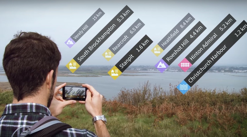
Augmented reality maps ensure you'll always know what that hill is called
Ever wondered the world would look like without sign posts, information points or road markings? It might not be that far away…
October 3, 2017

Ever wondered the world would look like without sign posts, information points or road markings? It might not be that far away…
Over at Ordnance Survey (OS) the team has decided to intertwine some augmented reality technology into its maps. It hasn’t gone as far as removing sign posts just yet, but it’s a nice little quirky idea which shows some of the potential for AR tech which hasn’t really caught on just about yet.
On the OS Maps application, users can now use their phone or tablet’s camera view to identify certain landmarks around the UK. Just hold out you camera and hills, mountains, coastal features, lakes, settlements, transport hubs and woodland in the vicinity are identified and labelled. Click on the label and a page of information about that location is displayed.
“This fantastic new feature really gives you a clear and accurate context of your environment,” said Tim Newman, Digital Product Manager at Ordnance Survey. “While we always recommend people carry a paper map when outside (they never run out of batteries!) we recognise that people are increasingly enjoying the benefits of using mobile phones for navigation.
“Mobiles can provide you with excellent knowledge of your immediate surroundings but you can lose the wider perspective on a small screen. The new augmented reality view helps address this by showing what is on the horizon. We hope people will find this fun and informative, as well as being a useful tool to help improve basic navigation skills.”
The feature is available in 200,000 locations throughout the UK, free to subscribers of OS Maps. It is augmented reality in action, and could offer some interesting ideas in terms of making money. Google is starting to see the benefits of investing in its Maps product, and there are some new advertising models which are starting to rise. Applying the same idea to augmented reality (i.e. selling reference points to local businesses), could generate some serious cash.
How often have you stood on a high street wondering where the nearest pub or café or tube station is? The first move is to pull up Google Maps and spin around in circles to get your directional bearings. This could be a more advanced version of that.
But it isn’t all about money. Think about the first question we asked. Imagine what your city would look like without sign posts, information points or road markings. It would be completely different. It might transform the high street, you’d actually be able to see the buildings! And then you pull out your phone and get hit by a wave of information and advertisements. Nothing comes for free.
About the Author(s)
You May Also Like


.png?width=300&auto=webp&quality=80&disable=upscale)

_1.jpg?width=300&auto=webp&quality=80&disable=upscale)


.png?width=800&auto=webp&quality=80&disable=upscale)